Big Sur on California's Highway 1 was cut off for three years, fully reopened on January 14, 2026, and then two wildfires burned into the coast in summer. This guide drives from Carmel to the elephant seals near San Simeon, stop by stop: where the 3 one-way traffic zones are and how long they last, how to see Bixby Bridge now that both ends are no-parking, what's open and closed at the state parks and McWay Falls, how to avoid the nearly-$10-a-gallon gas station, where to charge an EV, three rules for driving Big Sur, and a one-day plan.
Key facts
- Big Sur is open now, but with three one-way zones, and winter rain can close it anytime. Check Caltrans before you go.
- No parking at either end of Bixby Bridge. See it from the car, or stop only at official viewpoints.
- Fill up and charge before Big Sur. Don't buy 10-dollar gas on the road.
- After three years cut off, Big Sur is connected again. Information as of early November 2026; check the latest road conditions again before you go.
Video coming soon · Subscribe on YouTube
Understanding Big Sur
First, one minute to understand this road.
Big Sur is the roughly 90 miles of Highway 1 coast between Carmel in the north and San Simeon in the south. Ocean on one side, mountains on the other, and a single two-lane road in between.
Without stopping, it takes about two and a half hours. But gas stations are few, and most of it has no cell signal. Download offline maps before you go.
I suggest driving north to south. The ocean stays on your right, so at a viewpoint you just turn right to pull in, without crossing oncoming traffic.
Can you drive it now?
First, what happened to this road this year.
A landslide in early 2023 cut central Big Sur off for three years. On January 14 this year, three months ahead of schedule, the whole road reopened.
Then in August and late August, two wildfires broke out: the Timber Fire, about 25,000 acres, which burned partly into Pfeiffer Big Sur State Park, and the Plaskett Fire, about 30,000 acres, which reached near the county line. By early November both were largely contained.
Current conditions: according to Caltrans as of the evening of November 6, Highway 1 through Big Sur is not fully closed, but there are three one-way traffic zones. Rocky Creek Bridge, 24 hours a day, through November 30. Several spots near Point Sur Lighthouse, 24 hours a day, through December 31. And Mud Creek, weekdays 6:30 a.m. to noon, through November 13.
One-way control means signals let each direction through in turns, so you may wait ten-plus minutes at each. Allow extra time. In winter a heavy rain can close the road again at any moment. Before you go, check the Caltrans road site or call 1-800-427-7623.
Mile 0: Carmel
Mile 0, Carmel.
If you have time, loop the 17-Mile Drive first. It's a private scenic road, 12.50 dollars per car, open sunrise to sunset, no motorcycles. Spend 35 dollars at a Pebble Beach resort restaurant and the fee is refunded.
Three miles south of Carmel is Point Lobos State Natural Reserve. 10 dollars per car, 8 a.m. to 7 p.m., no entry after 6:30. No dogs, not even left in the car.
Bixby Bridge: no parking now
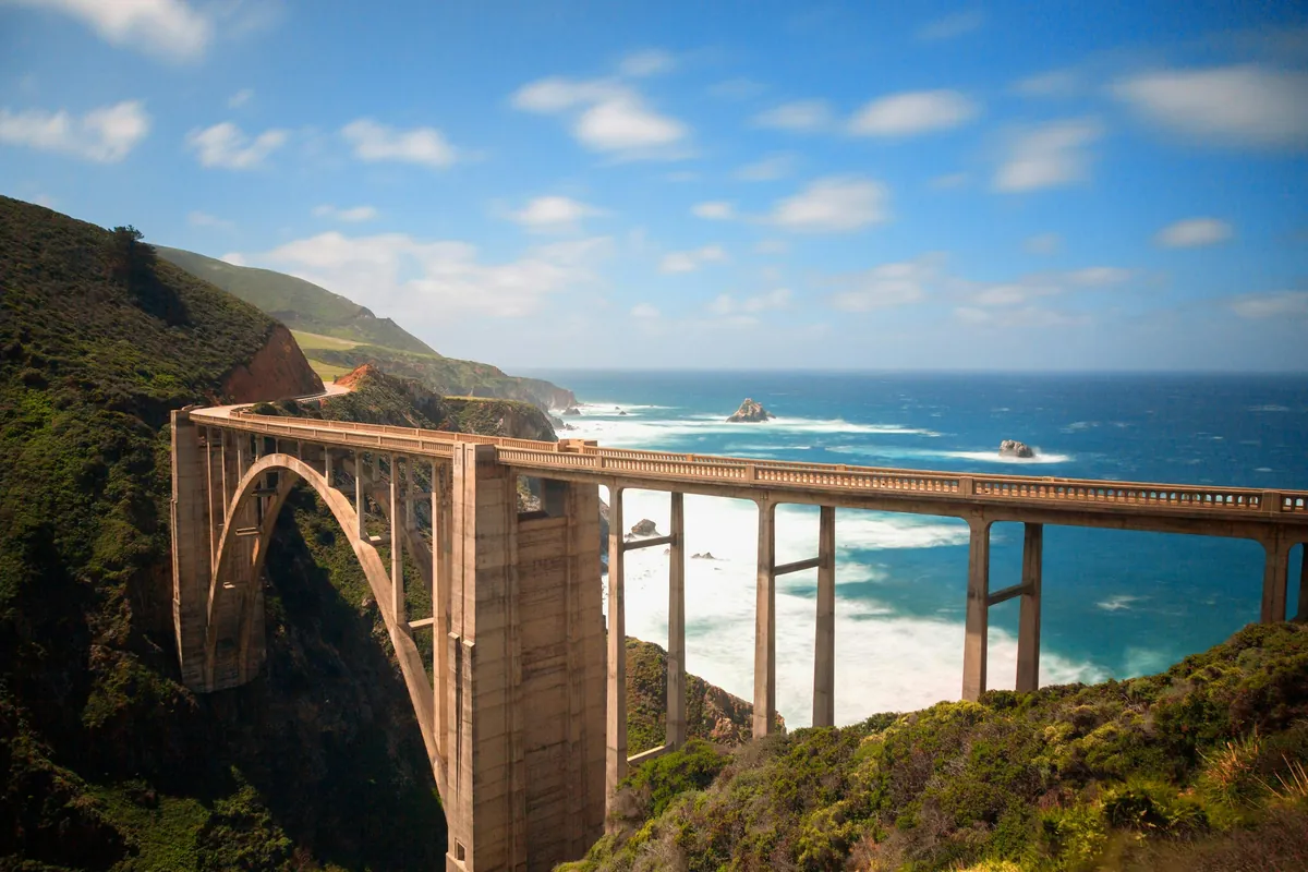
About 13 miles south is Bixby Bridge, the most famous bridge on Highway 1.
The reason is simple: so many people came to photograph the bridge that cars lined the shoulders and blocked the only road.
So how do you see it? One: drive north to south. It comes up shortly after Rocky Creek Bridge, and a passenger can watch and film from the car. Two: if you stop, use only official viewpoints or shoulders wide enough to get all wheels off the road, and never inside the no-parking zone. The county says it will study other parking options, so follow the signs on site.
Central Big Sur: what's open after the fires
Further south is central Big Sur, which changed the most after this year's fires.
Pfeiffer Big Sur State Park reopened on October 16, but six trails are still closed, including the Pfeiffer Falls trail.
Julia Pfeiffer Burns State Park is where you see McWay Falls. According to the state parks website on November 6, the park is open 8 a.m. to sunset, 10 dollars per car. The beach below McWay Falls is closed, there is no way down to the water, so never cross the fence. Trails on the east side of the highway are also closed.
Further south, Limekiln State Park is open, but its waterfall trail is still closed.
Which overlooks and trails are open changes quickly, so call the park or check the latest notices on the state parks website before you go.
Gas: nearly 10 dollars a gallon
Now the second question.
Gas stations in Big Sur are few and expensive. This April, a station in Gorda in the south charged about 9.40 dollars a gallon for regular and nearly 10 for premium. The owner said it's off the grid, runs on generators, and fuel is trucked in from over 100 miles away.
So the fix is simple: fill up in Monterey or Carmel before entering Big Sur. One tank easily covers 90 miles. Going south to north, fill up around Cambria or San Simeon. If you really run low, buy only enough to reach the next town.
Charging: fast chargers at both ends
EVs need even more planning.
At Ventana in central Big Sur there's a Tesla Supercharger: 8 stalls, up to 72 kilowatts. Not fast, but it can save you.
To the south, Cambria and San Simeon currently list only Level 2 chargers on charging maps, mostly at hotels.
So if you don't drive a Tesla, the safest plan is to charge full around Monterey before entering Big Sur, and leave plenty of buffer for 90 miles of climbs and air conditioning.
Three rules for driving Big Sur
Before the south end, three driving rules many people don't know.
One: slow vehicles must yield. California Vehicle Code 21656: on a two-lane road where passing is unsafe, if five or more vehicles are behind you, you must pull over at the nearest turnout or wide spot and let them pass. Big Sur is full of turnouts. Driving slowly to enjoy the view is fine, but when a line forms, pull over.
Two: when you park on the roadside, all four wheels must be off the road. Many curves have cliffs right outside; where there's no shoulder, don't stop.
Three: in one-way zones, follow the car ahead, don't pass, and don't stop for photos. Winter nights come early and there are almost no streetlights, so finish the drive before dark.
Mile 90: elephant seals
At the south end, about 7 miles north of San Simeon, is the Piedras Blancas elephant seal vista point. Free, no reservation, open every day.
Winter is the best time. In November adult males come ashore to fight for territory; December to March is pupping season, January is one of the peak months, with up to 17,000 seals.
Stay on the boardwalk and viewing areas, don't get close, and don't fly drones. Volunteers in blue jackets explain things on site daily from 10 a.m. to 4 p.m.
A one-day plan
If you only have one day, here's how I'd do it.
Leave Monterey in the morning after filling up and charging. See Point Lobos in the morning, then head south past Bixby Bridge, without stopping in the no-parking zone.
Have lunch in central Big Sur, and in the afternoon see McWay Falls at Julia Pfeiffer Burns. Winter days are short, so reach the elephant seal vista before sunset and stay in San Simeon or Cambria.
Allow time for the one-way zones; each one may add a wait.
General information only. Rules change; check official notices before you go.
Routes, parking and gas stations, shown on maps and real footage, one section at a time.